
Understand the USDA zone map, find your hardiness zone, and choose plants that thrive in your climate — a complete guide for beginner and experienced gardeners.
One of the first steps to successful gardening is knowing your USDA hardiness zone. Whether you’re choosing perennials for a flower bed, selecting fruit trees for your backyard, or deciding which shrubs will survive winter, the USDA zone map is your essential starting point. It tells you which plants can realistically survive your local winters — and which ones will likely die.
In this complete guide, you’ll learn exactly what the USDA plant hardiness zone map is, how to find your zone, what the zone numbers mean, and how to use this knowledge to make smarter planting decisions. We’ll also cover common misconceptions, the limitations of hardiness zones, and practical tips for gardening success in any climate.
What Is the USDA Zone Map?
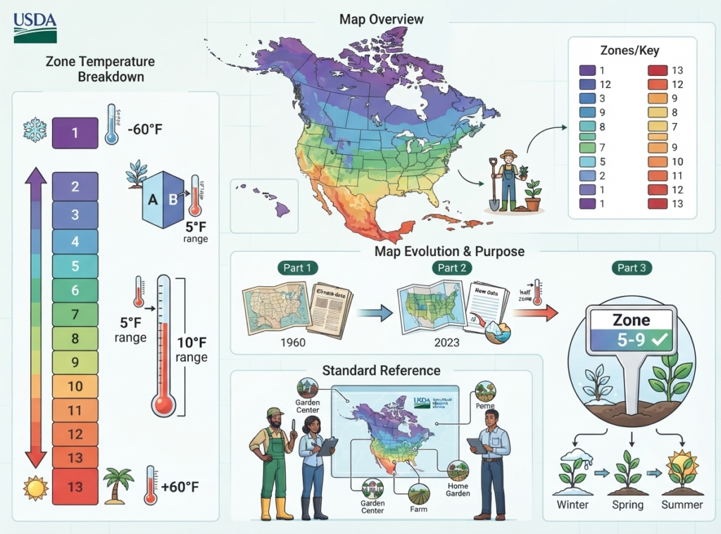
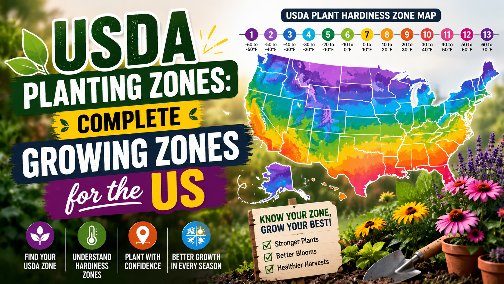
The USDA Plant Hardiness Zone Map is the standard reference used by gardeners, nurseries, and agricultural professionals across the United States to determine which plants are most likely to survive winter in a given location. Published by the U.S. Department of Agriculture’s Agricultural Research Service, the map divides North America into 13 zones based on average annual minimum winter temperatures.
Each zone represents a 10°F temperature range. Zone 1 is the coldest (interior Alaska, where temperatures can plunge to -60°F) and Zone 13 is the warmest (tropical areas where the minimum rarely drops below 60°F). Zones are further divided into ‘A’ (colder half) and ‘B’ (warmer half) subzones, each representing a 5°F range, giving gardeners more precise guidance.
The map was first published in 1960 and has been updated several times, most recently in 2023. Each update incorporates newer climate data, and many areas have shifted half a zone warmer over the decades — a reflection of changing climate patterns. When you see a plant label that says ‘Hardy to Zones 5–9,’ it means that plant is expected to survive winters in those zones.
How the USDA Hardiness Zone Map Works
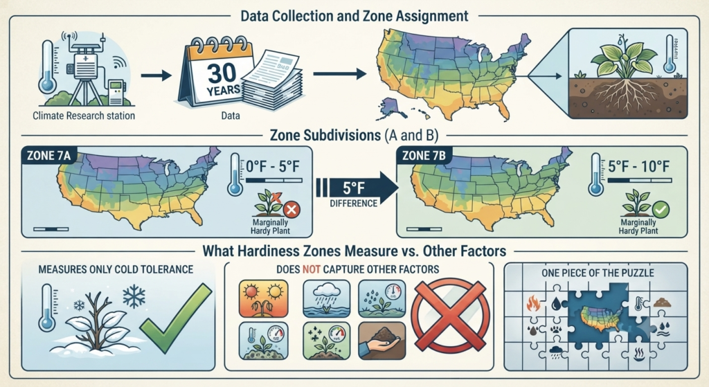
The hardiness zone map is based on one measurement: the average annual extreme minimum temperature. Researchers collect 30 years of weather data from thousands of stations across the country, calculate the average lowest temperature recorded each year, and assign zones accordingly. It’s a simple but powerful system for predicting whether a perennial plant’s roots can survive the coldest nights of winter.
Zone subdivisions (A and B) add precision. For example, Zone 7A experiences minimum temperatures between 0°F and 5°F, while Zone 7B ranges from 5°F to 10°F. This 5-degree difference can be meaningful — some marginally hardy plants survive in 7B but not 7A. Always check whether your area falls in the A or B subzone for the most accurate plant selection.
It’s important to understand that hardiness zones measure only cold tolerance — they tell you whether a plant can survive your winters, not whether it will thrive overall. Factors like summer heat, rainfall, humidity, and soil type are not captured by the USDA zone map. Think of it as one essential piece of the puzzle, not the complete picture.
USDA Hardiness Zone Chart
The table below shows all 13 USDA hardiness zones, their minimum temperature ranges, and example regions. Use this as a quick reference when shopping for plants or reading gardening guides.
| Zone | Min Temp (°F) | Min Temp (°C) | Example Regions |
|---|---|---|---|
| 1 | -60 to -50 | -51 to -46 | Interior Alaska |
| 2 | -50 to -40 | -46 to -40 | Northern Minnesota, Montana |
| 3 | -40 to -30 | -40 to -34 | Wisconsin, North Dakota |
| 4 | -30 to -20 | -34 to -29 | Iowa, Nebraska, parts of New England |
| 5 | -20 to -10 | -29 to -23 | Missouri, Illinois, Colorado |
| 6 | -10 to 0 | -23 to -18 | Kansas, Virginia, New Jersey |
| 7 | 0 to 10 | -18 to -12 | Oklahoma, North Carolina, Tennessee |
| 8 | 10 to 20 | -12 to -7 | Texas, Georgia, Pacific Northwest |
| 9 | 20 to 30 | -7 to -1 | Coastal California, Florida panhandle |
| 10 | 30 to 40 | -1 to 4 | South Florida, Southern California |
| 11 | 40 to 50 | 4 to 10 | Hawaii, Key West |
| 12 | 50 to 60 | 10 to 16 | Puerto Rico, tropical Hawaii |
| 13 | 60 to 70 | 16 to 21 | Tropical territories |
Remember that each zone is further split into A (colder) and B (warmer) subzones. For instance, Zone 6A covers -10°F to -5°F, while Zone 6B covers -5°F to 0°F. Your specific subzone can make the difference between a plant thriving or struggling through a harsh winter.
How to Find Your USDA Hardiness Zone
Finding your zone is simple. Visit the official USDA Plant Hardiness Zone Map at planthardiness.ars.usda.gov and enter your ZIP code. The interactive map will display your exact zone and subzone. You can also zoom into the color-coded map to see zone boundaries in your area. Many state university extension services provide local zone maps with even more detail.
Practical example: If you enter ZIP code 60614 (Chicago, Illinois), the map shows Zone 6A. This means your average annual minimum temperature is between -10°F and -5°F. When shopping at a nursery, you’d look for plants labeled ‘Hardy to Zone 6’ or lower — they’re designed to handle your winters. A plant labeled ‘Zones 8–11’ would not survive a Chicago winter outdoors.
Why Hardiness Zones Matter for Gardeners
Hardiness zones directly affect which perennials, trees, shrubs, and bulbs will survive year after year in your garden. Annuals complete their life cycle in one season regardless of zone, but perennials must endure winter cold to return the next spring. Planting a Zone 8 shrub in Zone 5 is essentially spending money on a plant that will die within months.
Understanding your zone also helps with landscape planning, budgeting, and long-term garden design. Trees and shrubs represent significant investments of time and money — a fruit tree takes years to mature. Choosing varieties rated for your zone means those years of growth won’t be lost to a single harsh winter. Nurseries, catalogs, and online plant retailers all use USDA zones as the standard reference.
Hardiness Zones vs. Frost Dates
Gardeners often confuse hardiness zones with frost dates, but they measure different things. Your hardiness zone tells you the coldest temperature your area typically reaches — it determines which perennial plants survive winter. Frost dates (last spring frost and first fall frost) tell you when it’s safe to plant frost-tender annuals and vegetables outdoors. You need both pieces of information for successful gardening.
For example, two gardeners might both be in Zone 7, but one in Tennessee has a last frost date of April 5, while another in the Pacific Northwest might have a last frost date of March 15. Same zone, different planting schedules. Use your hardiness zone to choose plants that survive winter, and your frost dates to time when you put them in the ground.
Hardiness Zones vs. Planting Zones: What’s the Difference?
The terms ‘hardiness zones’ and ‘planting zones’ are often used interchangeably in casual gardening conversation, and for most practical purposes they refer to the same USDA system. However, some gardening resources use ‘planting zones’ more broadly to include heat tolerance, growing season length, and other climate factors beyond just minimum winter temperature.
The American Horticultural Society publishes a separate Heat Zone Map that measures the number of days above 86°F — useful for understanding whether summer heat will stress certain plants. When someone says ‘planting zone,’ they almost always mean the USDA hardiness zone unless specified otherwise. When in doubt, ask which system is being referenced.
Common Gardening Mistakes with Hardiness Zones
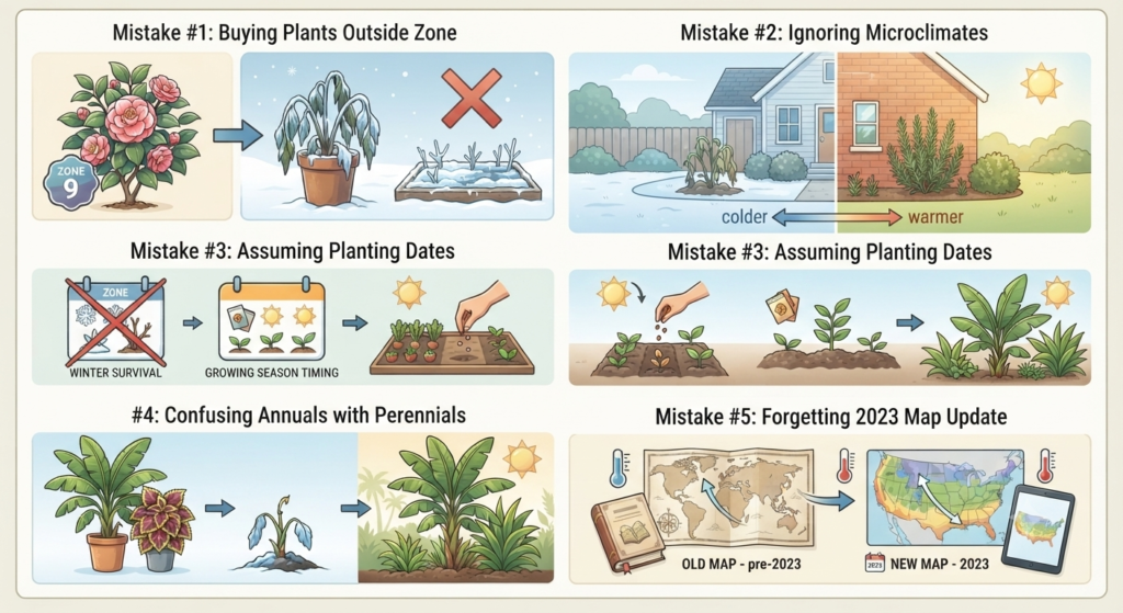
Mistake #1: Buying plants outside your zone because they looked beautiful at the nursery. That gorgeous Zone 9 camellia won’t survive a Zone 5 winter no matter how much you mulch it. Mistake #2: Ignoring microclimates. A south-facing wall, urban heat island, or sheltered courtyard can effectively push your zone half a step warmer — allowing you to grow marginally hardy plants. Mistake #3: Assuming USDA zones determine planting dates for vegetables and annuals. Zones tell you about winter survival, not growing season timing.
Mistake #4: Confusing annuals with perennials. A tropical plant sold as an ‘annual’ in Zone 5 is actually a perennial in Zone 10 — it just can’t survive your winter. Mistake #5: Forgetting that the USDA zone map was updated in 2023. If you’re using an old gardening book, its zone references may be outdated. Always check the current map for the most accurate information about your area.
What the USDA Zone Map Doesn’t Measure
The USDA hardiness zone map is based solely on average annual minimum winter temperatures. It does not account for: rainfall and drought, summer heat and humidity, soil type and quality, wind exposure, elevation changes, snow cover (which actually insulates roots), or the duration of cold spells. Two locations in the same zone can have vastly different growing conditions.
For example, Zone 8 includes both the rainy Pacific Northwest and parts of dry West Texas. A rhododendron that thrives in Seattle’s Zone 8 may fail in Lubbock’s Zone 8 due to completely different rainfall and humidity. Successful gardeners combine zone information with knowledge of local soil, rainfall patterns, and microclimate conditions for the best results.
Does the USDA Zone Map Apply Outside the United States?
The USDA zone map was designed for the United States and its territories, but gardeners worldwide reference it because most plant labels use USDA zone ratings. If you garden outside the U.S., you can still use the system — look up your area’s average annual minimum temperature and match it to the corresponding USDA zone number.
However, international gardeners should supplement USDA zones with local climate information. The UK’s Royal Horticultural Society, Australia’s climate zone system, and Canada’s own plant hardiness zones all account for regional factors that the USDA map doesn’t capture. Use USDA zones as a starting point for reading plant labels, then adjust based on your local conditions.
How to Read Plant Labels Using the USDA Zone Map

When you pick up a plant at a nursery, the label typically shows something like ‘Zones 5–9.’ The first number (5) is the coldest zone where the plant survives winter. The second number (9) is the warmest zone where it performs well — beyond that, winters may not be cold enough for dormancy requirements, or summers may be too hot. If your zone falls within that range, the plant should work for you.
Practical example: You’re in Zone 6B and you find a lavender labeled ‘Zones 5–8.’ Perfect — your zone is within range. But a crepe myrtle labeled ‘Zones 7–10’ is risky in your Zone 6B garden. It might survive mild winters but die in a particularly cold year. Some gardeners enjoy pushing zone boundaries with extra protection (mulch, sheltered spots), but it’s always a gamble.
Tips for Gardening Successfully in Your USDA Zone
Choose native plants whenever possible. Plants native to your region have evolved to handle your exact climate — the cold, the heat, the rain patterns, and the soil. They typically require less water, fewer amendments, and less maintenance than exotic species. Your local extension service or native plant society can provide region-specific recommendations.
Use mulch strategically. A 3–4 inch layer of organic mulch insulates roots from extreme cold in winter and retains moisture in summer. In colder zones, apply mulch after the ground freezes to prevent thaw-freeze cycles that heave roots out of the soil. In warmer zones, mulch helps retain moisture during dry periods. Avoid piling mulch against stems or trunks.
Monitor microclimates in your own garden. The south side of your house, areas near paved surfaces, and spots sheltered from wind can be half a zone warmer than exposed areas. Map these microclimates and use them to your advantage — plant marginally hardy species in warm pockets and cold-hardy varieties in exposed spots. Keep a garden journal to track what survives and what doesn’t.
Frequently Asked Questions
What is the USDA Zone Map?
The USDA Zone Map (officially the USDA Plant Hardiness Zone Map) divides the United States into 13 zones based on average annual minimum winter temperatures. It helps gardeners determine which perennial plants, trees, and shrubs can survive winter in their area. The map is published by the USDA Agricultural Research Service and was most recently updated in 2023.
How do I find my USDA hardiness zone?
Visit the official USDA Plant Hardiness Zone Map at planthardiness.ars.usda.gov and enter your ZIP code. The tool will display your exact zone and subzone (e.g., Zone 7A). You can also browse the interactive color-coded map to see zone boundaries across your state or region.
What is the difference between Zone 7A and Zone 7B?
Each USDA zone is divided into A (colder half) and B (warmer half) subzones, each representing a 5°F range. Zone 7A has minimum temperatures from 0°F to 5°F, while Zone 7B ranges from 5°F to 10°F. This difference can determine whether marginally hardy plants survive in your garden.
Does the USDA Zone Map change over time?
Yes. The map has been updated several times since its first publication in 1960. The most recent update (2023) shifted approximately half of the country into a warmer half-zone compared to the previous 2012 map. These shifts reflect 30 years of more recent climate data and generally warmer winter temperatures across much of the United States.
Can I grow plants outside my hardiness zone?
You can push boundaries by one half-zone using microclimates (sheltered walls, raised beds, urban heat), heavy mulching, and winter protection like burlap wraps. However, it’s always a risk. Plants rated for warmer zones may survive mild winters but die during unusually cold ones. For reliable results, choose plants rated for your zone or colder.
What is the warmest USDA zone?
Zone 13 is the warmest, with minimum temperatures between 60°F and 70°F (16°C to 21°C). It covers tropical U.S. territories like parts of Puerto Rico and Hawaii. Within the continental U.S., the warmest areas are Zone 10B and 11A in southern Florida and extreme southern California.
What is the coldest USDA zone?
Zone 1A is the coldest, with minimum temperatures below -60°F (-51°C). It covers remote areas of interior Alaska. In the contiguous United States, the coldest areas are typically Zone 3A, found in northern Minnesota, Wisconsin, and Montana.
Are planting zones and hardiness zones the same thing?
In most gardening contexts, yes — ‘planting zones’ and ‘hardiness zones’ refer to the same USDA system. However, some resources use ‘planting zones’ more broadly to include factors like heat tolerance and growing season length. When reading a plant label, the zone numbers almost always refer to USDA hardiness zones based on minimum winter temperatures.